How We Conduct Bathymetric Surveys?
Total Hydrographic are your certified Hydrographic Surveyors and Marine Mapping/GIS professionals.
Our Services
Bathymetric Surveys
Side Scan Sonar Surveys
Hydrographic Data Analysis
Terrestrial Surveying
Hydrographic Consultancy
Bathymetry is the study and mapping of the sea floor. Bathymetric surveys allow for us to measure the depth of a body of water as well as map its underwater features. Bathymetic data is used in a range of applications, some include:
- Hazard Detection
- Safety of Navigation and Nautical Charting
- Determiniation of Maritime Boundaries
- Environmental Management, including developing baseline data
- Research for Coastal and Marine Processes
- Installation of Maritime infrastructure
At Total Hydrographic we gather bathymetric data in a variety of different methods and equipment. Our Multibeam Echosounder (MBES) is a full bathymetric seafloor coverage system. The MBES system emits 512 beams in a fan shape beneath the boat allowing the system to capture up to 200,000 soundings per second and ensure maximum coverage of the seafloor.
Our Single Beam Echosounder (SBES) on the other hand, captures data using a single beam directly below where the system is mounted. Single Beam surveys are at a pre-defined line spacing; for example 2m, 5m, 20m. The size of these intervals determines the final resolution of the survey.
Multibeam survey and Single Beam surveys are each best suited to their own individual set of circumstances, locations and client needs. Total Hydrographic can help by recommending a particular solution specific to your own requirements and priorities as both MBES and SBES have their individual strengths and capabilities.
Hazard Detection and Debris Clearance
Hazard Detection and Debris Clearance is a necessary support service for any organisation that manages a body of water. It is crucial to identify new or existing obstructions from natural or anthropogenic events, and to determine safe recreational use for the public.
Our hydrographic survey team can offer bathymetric and side scan surveys that utilise in house R2Sonic Multibeam Echo Sounders (MBES) and/ towed or hull mounted Side Scan Sonars (SSS) to locate and identify hazards & debris. We can operate these systems concurrently or separately, to scan large swaths of river, sea, lake or dam beds in an efficient manner and provide detailed data on the hazards present in a format that best suits you.
Total Hydrographic maintains this equipment and capability in house and as a result, mitigates the risk of project delays. From the results of your survey, all hazards and debris will be located and identified, allowing you to be confident in what lies below the waterline.
Under Keel Clearance
Effective Under Keel Clearance management is a system put in place by Port and Harbour Authorities that mitigate the risk of a vessel’s hull running aground on the ocean floor. Regular Bathymetric and Hydrographic Surveys are undertaken to ensure that vessel navigation in shipping channels, berths and fairways are not put at risk. A keen understanding of depths within Port and Harbour waters is a great tool for making informed decisions on asset management, resource allocation and dredging programs.
Total Hydrographic’s survey team can utilise Single Beam Echo Sounders (SBES) and Multibeam Echo Sounders (MBES) to regularly perform Bathymetric surveys to the highest standard as set by the International Hydrographic Organization (IHO). Our MBES system can meet the requirement of a full seafloor search and can detect objects of features on the seabed.
If you are operating surface vessels with a significant draft then Under Keel Clearance is critical. You need to know what the shallowest depth is within the navigational passage and if your vessel can safely navigate across such shoals. Total Hydrographic can provide this information for you.
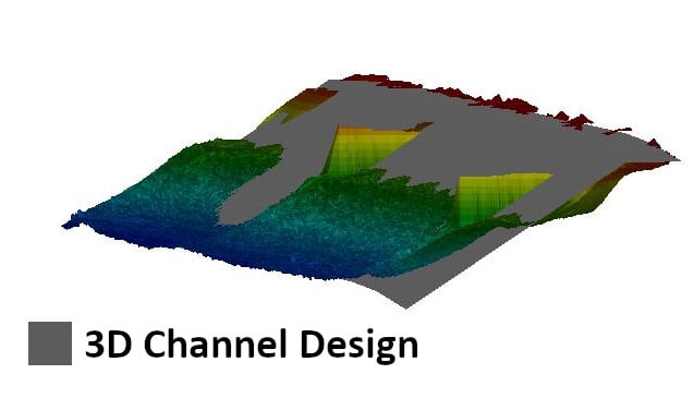
3D Channel Design
The objectives of the survey was to provide full bathymetric survey and provide a volume assessment for the renourishment site to meet the 3D design model. The data that we provided allowed the client to make an informed decision, based on quantitative and visual data presentation, as to the best mode of practice for dredging and renourishment operations.
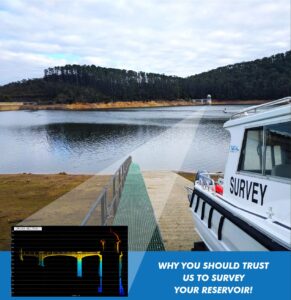
Reservoir Study
In a drought prone country like Australia, where millions of people rely on the country’s many reservoirs for a safe and dependable water supply – efficient, forward thinking and strategically planned reservoir management is crucial. The risk involved in reservoir management can be mitigated with quick access to relevant and accurate data.
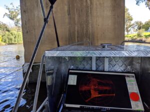
Underwater Inspection Survey
Total Hydrographic specialises in underwater survey and scanning and can utilise a variety of survey sensors to capture relevant data for clients. The Kongsberg MS1000 Mechanical Scanning Sonar used by Total Hydrographic is an example of a system that is ideal for inspecting underwater structures.
River, Creek and Estuary Surveys
Ensuring safe navigation in Rivers, Creeks and Estuaries is vital for authorities that manage commercial and recreational activities in these environments. Regular surveying in these dynamic bodies of water, is an effective tool to aid in managing these complex systems safety of navigation, natural/mineral assets, flood risk modelling, and environmental management policy.
At Total Hydrographic we can offer bathymetric and side scan surveys that utilise in house R2Sonic Multibeam Echo Sounders (MBES), Singlebeam Echo Sounders and towed or hull mounted Side Scan Sonars (SSS) to accurately measure depths, calculate dredge volumes and identify unseen hazards and debris. Our experience working in the Yarra River, helps us identify the challenges that can be posed by working in freshwater systems with highly variable tidal range, flow rate and salinity.
Our range of survey vessels are all installed with high accuracy RTK GNSS receivers, allowing for our surveyors to be mobile and accurate in all different freshwater and saline systems. We can also provide you with data in hard to reach places.
Installation of Tide Gauges or Water Level Infrastructure
Water levels and tides are usually highly dynamic by nature. When your asset is affected by tides or water levels then it is crucial that you accurately know the levels in real time. It is critical to have this information at your fingertips if you manage a port facility. Using predicted tides requires a large error buffer to be considered compared to using real time observed tides. The result is a substantial increase in the Under Keel Clearance that could be available within your facility.
Total Hydrographic use of a reputable supplier of tide gauge equipment and can ensure the gauge is installed accurately back to the desired datum. Understanding tides and datums means that we can install your gauge efficiently by getting it right the first time around.
With the latest gauges being web based you will have up to date tide and water level information in the palm of your hand. You will be able to make accurate and informed decisions and reduce any delays in executing tasks.
Scouring and Asset Inspection of Structures
Scouring and Erosion are natural processes when working in dynamic coastal and freshwater environments, left observed this can lead you to calling for major infrastructure and civil engineering works. Surveying of the underwater conditions of bridge/wharf/peir struts and columns is a great way of appropriately managing and maintaining your assets’ health.
Surveys in this field can consist of Singlebeam Echo Sounder (SBES) surveys, Multibeam Echo Sounder (MBES) surveys, Side Scan Sonar (SSS) surveys and Mobile Laser Scanning (MLS) surveys. When using MBES, SSS and MLS, concurrently we are able to scan in high resolution and overlay with SSS imagery to allow you to pinpoint faults, cracks and scouring of structures support all in a full georeferenced 3D point cloud that is connected to the survey datum.
These survey capabilities reduce the risk to divers working in high turbidity environments and allow you to interrogate your asset in more detail. You can also quantify the magnitude of scouring that has taken place and determine what volume of fill is required to correct the scouring.
Harbour Dredging
A corner stone of Total Hydrographic’s operations is to provide underwater survey solutions that can help Port and Harbour Authorities determine an appropriate dredging solution for their waterways. Dredging solutions often takes place because of sedimentation gradually encroaching in navigable waterways, and or when Port and Harbour authorities look to expanding their operations.
A Rockwall
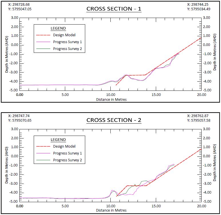
The results from a rock wall scanning project were processed and thoroughly analysed. The scan was undertaken to validate that the rock wall had been accurately constructed as per its design. Cross Section Profiles were extracted from this data and can be seen in the images.
Submerged Trees
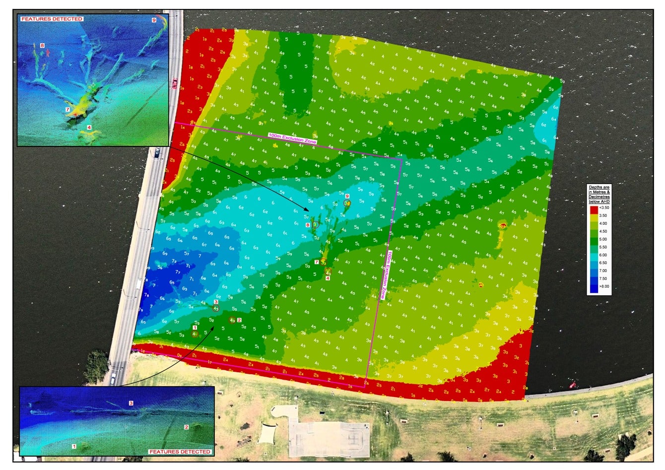
This image is an extract from a hazard clearance survey of a lake. The client needed to know that there was a minimum clearance depth of water available at particular water levels. There were many hazards on the lake bed, however the survey revealed that they were all deeper than the client’s required minimum depth.
Underwater Scanning with Multibeam Echo Sounder
The most challenging part of managing an underwater asset is that you generally can’t easily do a visual inspection of the asset. Monitoring material movements and the foundations of your asset can be crucial in ensuring their integrity. With flowing water, scouring can be a big problem and can take place quickly in extreme marine environments.
Multibeam Echo Sounders (MBES) are a great solution for quickly scanning underwater assets and Total Hydrographics in house R2Sonic MBES is well suited for scanning a range of underwater assets. It is mounted to a vessel in a unique way that enables both efficient coverage and optimised scanning capability by the sonar head being mounted at an angle more suited for vertical structures.
When a multibeam scan is completed you will get a full 3D point cloud model that enables you to get amongst your asset and fully analyse the asset in its environment. All our data is georeferenced so that repeat surveys can be compared with each other to monitor changes (to both the underwater asset and the environment) over time.
Dredging & Renourishment Support and Monitoring
Dredging is an essential process that Port and Harbour authorities, Marine Facility Managers and other marine stakeholders can utilise in maintaining their waterways to ensure safety of navigation. Renourishment of beaches is a frequent task undertaken by local councils and foreshore organisations.
Bathymetric surveys with our in house Mulitbeam Echo Sounder (MBES) and Singlebeam Echo Sounder can be useful tools for pre, progress and post dredge monitoring and analysis. When surveying beaches, Total Hydrographic use an RTK GNSS rover survey, on foot. It is one of the only ways of capturing data in the surf zone where a vessel can’t get to and aerial photogrammetry does not work. We have been successfully responsible for providing dredging services to major port authorities such as the Victorian Regional Channel Authority’s Geelong Channels as well as local Harbour, Marina and Coastal Foreshore authorities.
A cornerstone of our work is based around these surveys, so we are adept and experienced at working in shallow coastal environments, as well as busy ports and harbours to bring you data that can help maintain safety of navigation and enhance your facility’s functionality.
Dam Asset Management and Reservoir Surveys
Strategic Planning, monitoring and maintenance of Dams and Reservoirs is made easier by regular bathymetric and hydrographic surveys. The ability to determine accurate volume calculations from surveying allows you to make informed decisions about water supply needs and manage mitigation strategies with more confidence.
We are able to provide bathymetric, sub bottom and topographic surveys of Reservoirs and their surrounding. Bathymetric and Sub Bottom data capture can be achieved using our in house Singlebeam Echo Sounders (SBES) or Multibeam Echo Sounders (MBES). Topographic data can be captured using Mobile Laser Scanning from our vessel, drone photogrammetry or airborne LiDAR.
Our services include merging these above and below water data sets to give you full coverage of your asset, current capacity calculations, water volume capacity tables and graphs, 3D modelling of reservoir bed contours and 3D modelling of man made infrastructure to determine sedimentation and scouring. A comprehensive survey and its deliverables, can help mitigate and manage water supply risks more effectively.
Compliance Chart
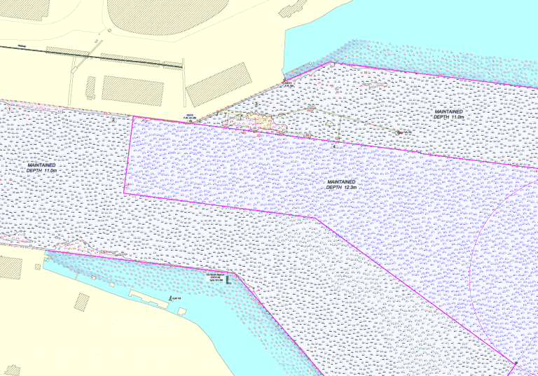
In a port environment declared channel depths take utmost importance. Quite often a port will focus their attention on whether their channel is as deep as the depth it is declared. Here we can assist by streamlining our results. A Compliance Chart provides a clean interpretation of whether depths are compliant or non-compliant.
Yacht Club Survey
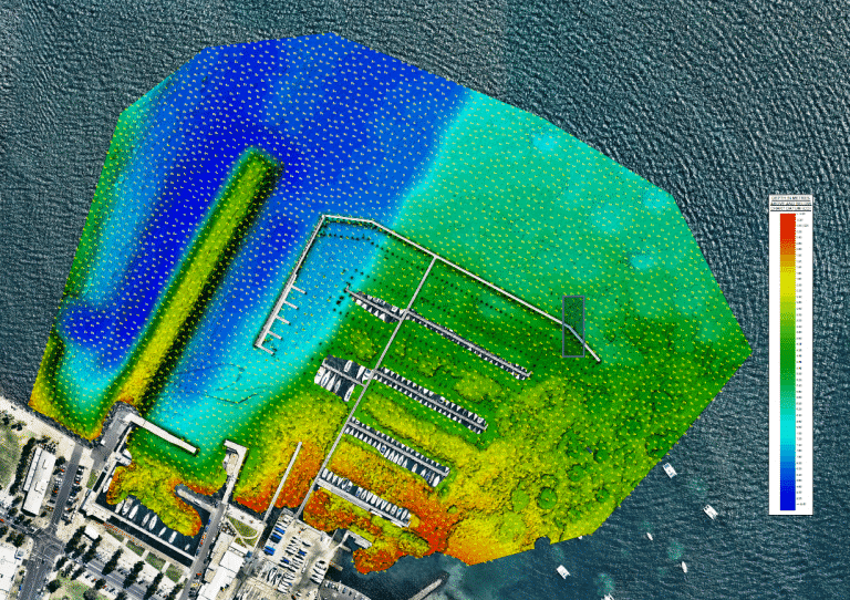
Multibeam survey data can be presented in many ways. 3D contours are often a great way of presenting what is happening on the seabed. This Yacht Club survey not only reveals the depths but also the old pier alignment and extensive aquatic vegetation in the southern shallows.
Habitat Mapping
This is an example of a habitat mapping project carried out by Total Hydrographic. An MBES survey was undertaken and then several outputs were delivered to the client. The information clearly reveals the location of the reef outcrop to the north and then the sandy bottom to the south. The backscatter highlights the variations in the seabed within the sand area outside of the reef.
Search and Rescue or Reconnaissance
When objects fall from vessels or from marine infrastructure they quickly become invisible to anyone on the surface. These objects can then be moved by subsurface currents and end up in a different location. These objects can be hazards to vessel navigation or could be in need of rescue and need to be found urgently.
Bathymetric survey using multibeam echo sounders (MBES) is a great way to search the seafloor for missing objects. Total Hydrographic has a dual head MBES that enables improved searching capabilities and efficiency, especially in shallow waters. We can couple this system with Side Scan Sonar to effectively undertake a swath search of a body of water. Divers are often used in search and rescue but are restricted by visibility and can be slow to cover large areas. Sonar has the capability to work in these low visibility environments and can cover large areas quickly.
Sonar surveys will enable a large expanse of water to be searched extremely quickly. When targets are detected via the sonar survey, divers can be sent straight to the target for rapid detailed inspection.
Marine Habitat Mapping
Total Hydrographics Marine Habitat Mapping services are there to support clients whose focus is to discover the characteristics of our oceans nearshore benthic habitats. Our services help clients make informed decisions on seabed classification, asset management and environmental protection policy, through the collection of a variety of different bathymetric and hydrographic data sets.
Our R2Sonic Mulitbeam Echo Sounder (MBES) system can obtain bathymetric data and backscatter intensity of the acoustic signals from the sea floor. Seafloor acoustic reflectivity is a measure of the acoustic energy returning from the seafloor, different reflective signals and properties of seabed strata are detected in our MBES backscatter data that helps for creating categorical maps of the seabed. MBES bathymetry and backscatter data help build cohesive marine habitat data sets.
Our finished product is able to provide a properly presented habitat map that will be able to reveal the diversity, distribution and classification of your area of interest. This map can serve as a useful tool for biological and marine planning and management.
Coastal and Foreshore Development
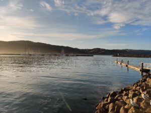
Coastal and Foreshore authorities often are looking for reliable survey data to make informed decisions about flood management, erosion mitigation and resource consents. With seasonal variation in met/ocean conditions and the unpredictability of storm events means that annual or regular bathymetric and topographic surveys are able to provide detailed information about sedimentation and erosion, offshore to beach topography, and volume calculation to meet potential channel designs.
Our surveys can consist of using Singlebeam Echo Sounders (SBES), Multibeam Echo Sounders (MBES), on foot RTK GNSS beach profiling and Mobile Laser Scanning (MLS). The in house 2.2m Mercury inflatable and 4.0m monohull aluminium hull means that we can deploy and be extremely effective in shallow waters. With running on water and on land survey techniques concurrently we are able to collect and integrate seamless data across your extents.
Ensure your coastal and foreshore development project stays on track with reliable survey data. The surveys we have undertaken of this nature have been for local and regional councils/authorities across Victoria.
3D Channel Design
The objectives of the survey was to provide full bathymetric survey and provide a volume assessment for the renourishment site to meet the 3D design model. The data that we provided allowed the client to make an informed decision, based on quantitative and visual data presentation, as to the best mode of practice for dredging and renourishment operations.
Reservoir Study
In a drought prone country like Australia, where millions of people rely on the country’s many reservoirs for a safe and dependable water supply – efficient, forward thinking and strategically planned reservoir management is crucial. The risk involved in reservoir management can be mitigated with quick access to relevant and accurate data.
Underwater Inspection Survey
Total Hydrographic specialises in underwater survey and scanning and can utilise a variety of survey sensors to capture relevant data for clients. The Kongsberg MS1000 Mechanical Scanning Sonar used by Total Hydrographic is an example of a system that is ideal for inspecting underwater structures.
Sub Bottom Profiling
Total Hydrographics sub bottom profiling services are there to assist those who are looking for detailed information on sedimentation in dams, rivers or lakes, subsurface geology and stratification of seabed substrates. We can also capture information on a variety of other geological, geophysical and hydrogeological applications.
Our in house dual frequency Singlebeam Echo Sounder (SBES) is an effective tool in identifying sedimentation information for shallow water bodies, such as inlet ponds on industrial sites or overflow ponds at water recycling plants. If your survey requirements are for more detailed information on sediment layers and sub bottom geomorphology, we have previous experience with utilising shallow water sub bottom profilers that have 10 times the penetration capacity of our SBES system.
The range we store in house allows us to deploy in nearly all environments, mitigating the risk of time delays for your project. Either way we can provide a solution for mapping your subsurface layers.
Join Our Newsletter
Address
14/75 Endeavour Way, Sunshine West VIC 3020
79 Cook Road, Bli Bli, 4560, QLD

