Water covers nearly 70% of the earth’s surface. Navigating safely over the ocean’s surface depends on an understanding of the seabed and subsurface topography. Hydrographic surveying – which involve underwater surveys and studies – provide this type of information.
What Is Hydrographic Surveying?
An underwater survey examines a wide range of features. It is also known as underwater surveying. Study and investigation are conducted regarding the topographic features, water depths, and tide measurements. It is important to know and understand the contours and elevations of ocean beds for a variety of practical purposes. Hydrographic surveys are sometimes called bathymetric surveys.
Bathymetry includes a moving vessel to carry out various measurements, unlike land surveys, where stationary equipment is utilised. For any issue or error that may arise in this motion, unique allowances must be made and data processed and interpreted.
Purpose of Hydrographic Surveying
Water Depth Calculation
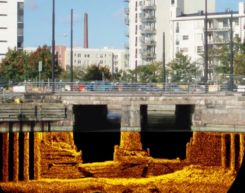
Bathymetric surveys are used to calculate water depth, which is the main objective of hydrographic surveys. Hydrographic surveys can also be used to evaluate dredging operations, plan canals, and locate wrecks. Harbours, docks, and dams are also constructed using these surveying technics. To make sure that all ships can safely berth and enter ports, it is imperative that the water depth in and around ports is adequate. A strong foundation must also be present in the parts of the seabed that support floating structures. To ensure the actual strength of the structure, dams must also have the appropriate information and knowledge of the terrain surrounding them. Engineers use these surveys to plan reclamation activities as well. Sites that can be reclaimed can be selected based on seabed topography and composition data.
Future resource planning
Engineers can conclude the possibility of projects in the phase planning. The process of surveying also helps in flood control systems, by expecting the possible flooding areas and also suggesting measures to counter this effect. Flooding zones can also be predicted by examining and studying how sea floor changes near the coastline and by comparing the structure with any records of tsunamis or flooding.
Beach Re-nourishment
Another application of deepwater surveying is identifying shorelines that expand around a coast. Preparation of shoreline charts that are useful in conducting different studies on the consequences of water bodies on land, and when it comes to determining the real maritime border of different countries. Surveying also identifies the actual sea level that has a very vital role in every sphere of life. From helping the government in the process of charting coastlines, they also affect the launch of rockets and space shuttles.
Hazard Detection
Along with surveying, debris clearance and hazard detection are also crucial support services for any company that manages any water body. It is vital to recognise existing or new obstructions from anthropogenic or natural events and to examine safe use for the public. Moreover, marine habitat mapping services are also provided by Total Hydrographic to support our clients who want to discover the new characteristics of oceans near-shore benthic environments.
Conclusion
Total Hydrographic services help our clients to make strong and informed decisions on asset management and seabed classification, the policy of environmental protection, with the collection of a great variety of several hydrographic and bathymetric data sets. Marine habitat mapping is also a great example of a set that is applied in field methods that provides support to EBM directly and also contributes important elements for executing enhanced ecosystem assessments.
Recent Comments